Maps
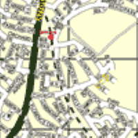
map 500m:1 scale (500m : 1m)
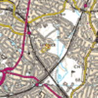
map 1k:1 scale (1k : 1m)
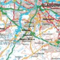
map 10k:1 scale (10k : 1m)
We are located in the centre of each map.
Getting Here
By Car
From M8 take the M77 (Kilmarnock) then A726 towards (East Kilbride), travel 1.5 miles and at second roundabout (EASTWOOD TOLL) turn left (A77 Glasgow) then take 5th road on the right (Church Road), 6th road on right into Forres Avenue.
From Glasgow Airport go through Airport Terminal join M8 for Glasgow, take A741 Paisley then A726 for East Kilbride, at 2nd set of traffic lights turn left still on A726 travel 6.5 miles and at EASTWOOD TOLL roundabout turn left (A77) Glasgow, take 5th road on the right into Church Road then 6th road on right into Forres Avenue.
From M74 (by passing city) follow A725/A726 (Paisley) to EASTWOOD TOLL roundabout, turn right (A77 Glasgow) take 5th Road on right (Church Road) then 6th road on right into Forres Avenue.
From Stranraer/Cairnryan/Prestwick Airport take the M77/A77 at (EASTWOOD TOLL) roundabout go straight accross (Fenwick Road/A77 Glasgow) then take 5th road on the right (Church Road), 6th road on right into Forres Avenue
By Train
From Glasgow Central Station take the East Kilbride train, alight at Giffnock Station. Through gate into Forres Avenue.
By Bus
From Glasgow city centre take the No. 38 from Renfield Street/Union Street (Destination Darnley) or No. 4 from Buchanan Street Bus Station (Destination Ayr). Alight at Safeway, Giffnock. 1st left into Station Road and over the footbridge into Forres Avenue.